Home › Location Inside the Bengaluru search area, Assetz Miru & Miyo helps buyers keep the map conversation grounded in actual routines instead of only distance claims.
Location
Asian Fab Kengeri Location
Asian Fab Kengeri is the working title used on this site; Asian Fab Tec Limited has not announced a marketing name for the development. What the company has done is file for it — twice — and those filings are where the location on this page comes from. Everything below is drawn either from the Standard Terms of Reference granted on 8 July 2026 by SEAC Karnataka, or from a routed road-distance table built from the site's published coordinate. Nothing here is drawn from a listing portal or from the marketing material circulating about the project.
That distinction matters more than usual on this page, because the early material circulating about this scheme gets the location details wrong in at least two ways that a buyer would eventually have to unpick at a sub-registrar's counter. We have corrected both, and we explain the correction rather than quietly applying it.
The address on the filings: Doddabele Village, Kengeri Hobli, Bangalore South Taluk
The parcel is not a street address. It is a revenue-record address, and this is how the granted Terms of Reference sets it out.
| Field | Value |
|---|---|
| Village | Doddabele (LGD/census village code 613024) |
| Hobli | Kengeri Hobli |
| Taluk | Bangalore South Taluk |
| District | Bengaluru Urban |
| Postcode | 560060 |
| Survey numbers | Sy No. 7/2, 7/3, 7/4, 7/6, 7/1A, 7/1B |
| Land extent | 6.2624 ha, which is 15.47 acres |
| Land classification | Privately owned, acquired, classified residential land, with DC conversion on file |
The conversion entry on the file reads "CONVERSION SYNO-72, 73, 74, 76, 71A, 71B" — the same six survey numbers written without their slashes. That is the ordinary way a conversion order is transcribed into a filing, and it lines up with the survey list.
On the spelling. The filings and the census both read Doddabele. The early material in circulation writes it "Doddabale", and that is wrong. We use Doddabele throughout this site. If you are searching revenue records, RTC extracts or encumbrance certificates, search on Doddabele; the alternative spelling will not reliably return the same records.
Why the taluk, hobli and pincode are not decoration. A residential parcel in Bengaluru Urban district is a different animal from one in Ramanagara or Bengaluru Rural, and the boundary in this belt is closer than most buyers assume. The taluk determines which sub-registrar's office holds the encumbrance history and where the sale deed is presented. The hobli determines which revenue records apply. The pincode, 560060, is the practical test a buyer can run in a minute: if a document about this project shows a different taluk, a different district or a different pincode, it is either about a different parcel or it is careless, and either way it should not be relied on.
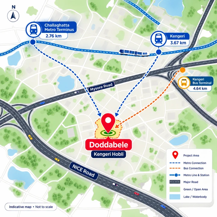
What Asian Fab Kengeri's published coordinate actually is
We publish one coordinate for this site:
12.89549, 77.47207
We want to be exact about what that number is, because a map pin looks like a fact and this one is an estimate.
It is the centre of the bounding box of the parcel boundary file the developer itself lodged with PARIVESH. That KML boundary box runs from latitude 12.8939848 to 12.8970023 and from longitude 77.4703953 to 77.4737428. The box measures roughly 334 m by 363 m, and the filed parcel fills about 52% of it. So the point we publish is the centre of a rectangle drawn around an irregular shape — not a surveyed centroid, and not the site entrance.
That gives it a working accuracy of a couple of hundred metres, which is honest enough for judging a corridor and useless for judging a boundary wall. We register it as inferred, medium confidence, we never write more than five decimal places, and we never call it the centroid. It is the best publishable point available for this parcel and that is the whole of the claim.
The coordinate in the circulating client material is wrong and we have discarded it. It falls outside the developer's own filed bounding box, which is a hard disqualification — a pin cannot be inside the parcel if it is outside the box the parcel was filed inside. We do not reproduce that coordinate anywhere on this site, and any map keyed to it is pointing at the wrong ground.
The Plus Code carried in the same material, VFVC+QXR, does fall inside the filed bounding box, so it is at least consistent with the filing. Whether it falls inside the parcel boundary itself is not determinable from anything we can obtain: the polygon enclosure on PARIVESH is authentication-gated and could not be retrieved. That is a genuine gap and we are not going to paper over it.
The road Asian Fab Kengeri fronts, and the one it does not
Three different roads get collapsed into one another in material about this corridor, and the difference is worth real money.
| Road | What it is |
|---|---|
| Mysore Road | The old SH-17 alignment, since renumbered NH-275. This is the at-grade arterial through Kengeri that carries local traffic, buses and frontage development. |
| Doddabele village road | The local road off Mysore Road by which the site is reached. |
| Bengaluru–Mysuru Expressway | A separate, access-controlled six-lane alignment whose Bengaluru terminus is the NICE Road junction near Kengeri. Entry is only at its interchanges. |
The site does not front the expressway. It is reached off Mysore Road, the NH-275 alignment, via the Doddabele village road. Nothing in the documents we hold describes the plot as fronting Mysore Road itself either, and we are not going to assert a frontage that no filing states. What can be said accurately is that the parcel sits behind the Mysore Road corridor and takes its access from it through a village road.
The practical consequence is about entry points, not about the expressway existing. An access-controlled road only helps you where it lets you on. The nearest routed reference we have to that alignment is the Nandi Infrastructure Corridor Enterprises entry — NICE Road — at 6.02 km by road, against a straight-line separation of 2.86 km. That is a detour ratio of 2.10: the road distance is more than double the map distance, which is exactly the signature of a controlled-access corridor you have to drive around to get onto.
Metro and rail from Asian Fab Kengeri
This is the strongest connectivity fact the location has, and it is a verified one.
| Destination | Routed road distance | Detour vs straight line | Time range (free-flow floor to peak ceiling) |
|---|---|---|---|
| Challaghatta metro station | 2.76 km | ×2.32 | 4–10 min |
| Kengeri railway station | 3.67 km | ×1.33 | 5–13 min |
| Kengeri Bus Terminal | 4.64 km | ×1.69 | 7–17 min |
| Jnanabharati metro | 7.12 km | ×1.17 | 9–26 min |
| Pattanagere metro | 7.68 km | ×1.79 | 10–28 min |
| Rajarajeshwari Nagar metro | 8.64 km | ×1.25 | 10–31 min |
| Nayandahalli metro | 9.27 km | ×1.26 | 12–33 min |
| Mysore Road metro | 9.71 km | ×1.14 | 12–35 min |
Challaghatta at 2.76 km by road is the single most useful thing about this address. It is the operational western terminus of Namma Metro's Purple Line, which means a resident boards at the start of the line rather than partway along it.
Two caveats we will not soften. First, it is not walking distance. At 2.76 km by road it is a feeder, an auto or a two-wheeler ride, and anyone describing a metro terminus at that distance as walkable is describing the straight-line figure, which is 1.19 km. Second, that gap between 1.19 km on the map and 2.76 km on the road is a detour ratio of 2.32 — one of the largest in the whole routed set. The station looks close on a map and drives more than twice as far. Budget for the road number, not the map number.
Kengeri railway station at 3.67 km adds suburban rail as a second, independent public-transport option. Kengeri Bus Terminal follows at 4.64 km.
Employment: what is near Asian Fab Kengeri and what is not
We will be plain about this. The Mysore Road corridor is not one of Bengaluru's large IT employment belts, and the routed table does not pretend otherwise.
| Destination | Routed road distance | Detour |
|---|---|---|
| Sattva Global City (Global Village Tech Park campus) | 5.71 km | ×1.40 |
| Nandi Infrastructure Corridor Enterprises (NICE Road) | 6.02 km | ×2.10 |
| Rexroth | 6.96 km | ×1.39 |
| Virtual Logic Systems | 10.63 km | ×1.39 |
The Global Village Tech Park campus at 5.71 km by road is the one substantial office concentration inside a short drive. Everything else in the routed employment set is either a single company address or an institutional one.
What we are not going to do is quote a distance to Whitefield, Electronic City, the Outer Ring Road tech belt or Manyata. None of those appears in the routed table for this site, and a figure we have not routed is a figure we do not publish. If your work is in one of those corridors, the honest answer is that this is a cross-city commute and you should route it yourself, at your own commute hour, before you commit. The metro terminus helps that case materially more than a car does — but only for destinations the Purple Line serves.
Schools near Asian Fab Kengeri
| School | Routed road distance | Detour |
|---|---|---|
| Basava Residential Girls School | 1.42 km | ×2.22 |
| S.G.K. Modern Public School | 3.07 km | ×5.18 |
| Marigold International School | 4.18 km | ×2.09 |
| St. Theresa's School | 4.29 km | ×1.71 |
| National Public School, Kengeri | 4.52 km | ×1.29 |
| Bethesda International School | 4.78 km | ×1.22 |
| Chinmaya Vidyalaya, Banashankari | 5.13 km | ×2.72 |
| Orchard International School | 5.39 km | ×1.23 |
| Orchids The International School, Mysore Road | 5.40 km | ×1.23 |
| BGS Public School | 6.13 km | ×2.15 |
| Sunrise International School | 6.55 km | ×2.30 |
| NPS Mysore Road | 8.10 km | ×1.97 |
The school set is where the map lies hardest. S.G.K. Modern Public School is 0.59 km away in a straight line and 3.07 km by road — a detour ratio of 5.18, the worst in the entire routed table for this site. The road simply does not run that way. A parent looking at a map would plan a short walk and end up with a school run. The same pattern holds for Chinmaya Vidyalaya Banashankari (1.89 km on the map, 5.13 km by road) and Sunrise International (2.84 km on the map, 6.55 km by road).
Basava Residential Girls School at 1.42 km by road is the genuinely close one, though even that carries a ×2.22 detour against its 0.64 km straight-line separation.
Colleges and higher education around Doddabele
This pocket is unusually dense in higher education, and that is a real characteristic of the location rather than a marketing line.
| Institution | Routed road distance | Detour |
|---|---|---|
| ACS College of Engineering | 1.73 km | ×1.99 |
| Fiscal Policy Institute | 3.02 km | ×4.45 |
| IBS business school | 3.13 km | ×3.41 |
| St. Benedict's Academy | 3.75 km | ×2.42 |
| SBS PU and Degree College | 3.90 km | ×1.49 |
| Rajarajeswari Dental College and Hospital | 4.72 km | ×1.90 |
| Rajarajeshwari College of Engineering | 4.73 km | ×1.80 |
| JSS Academy of Technical Education | 6.36 km | ×1.74 |
| R. V. College of Engineering | 7.91 km | ×1.81 |
| IIHS Kengeri Campus | 8.05 km | ×1.79 |
| Christ University, Kengeri Campus | 8.56 km | ×1.62 |
ACS College of Engineering at 1.73 km is the nearest campus of any size. The Fiscal Policy Institute sits 0.68 km away in a straight line but 3.02 km by road, a ratio of 4.45 — another case where the map and the road disagree violently.
A dense college belt has two consequences a buyer should price in honestly: a durable rental market from students and staff, and academic-calendar traffic on the local roads that a resident will feel twice a day during term.
Healthcare within reach of Asian Fab Kengeri
| Facility | Routed road distance | Detour |
|---|---|---|
| HK Hospital | 1.77 km | ×1.10 |
| Rajarajeshwari Hospital and Medical College | 2.44 km | ×2.21 |
| Belaku Eye Hospital | 2.74 km | ×1.42 |
| Mathru Hospital | 2.79 km | ×1.42 |
| Kengeri Upanagara Government Hospital | 3.31 km | ×1.36 |
| SDM Institute of Ayurveda and Hospital | 3.62 km | ×2.24 |
| Shreya Hospital | 4.04 km | ×1.29 |
| Adarsh Hospital | 4.42 km | ×1.41 |
| BGS Gleneagles Hospitals | 6.25 km | ×2.17 |
| Manipal Speciality Hospital | 7.69 km | ×1.62 |
| Fortis Hospital, Nagarbhavi | 10.32 km | ×1.24 |
Healthcare is the strongest everyday-amenity category here. HK Hospital at 1.77 km has a detour ratio of just 1.10 — the road distance is barely longer than the straight line, which means a direct approach with no barrier to work around. For an emergency run that matters more than the raw kilometres.
One data note, in the interest of not overstating precision: the Rajarajeshwari campus appears twice in the underlying map data under two names, routing to 2.44 km and 3.25 km. Rather than pick one and present it as the figure, treat the campus as 2.44 to 3.25 km by road.
Tertiary care is present but not close: BGS Gleneagles at 6.25 km (with a ×2.17 detour that again doubles the map distance), Manipal Speciality at 7.69 km, Fortis Nagarbhavi at 10.32 km.
Retail, everyday needs and open water near Doddabele
| Destination | Routed road distance | Detour |
|---|---|---|
| YGR Signature Mall | 7.61 km | ×1.62 |
| Gopalan Arcade Mall | 8.85 km | ×1.33 |
| Anchepalya Lake | 3.44 km | ×2.13 |
| Kengeri Lake | 3.82 km | ×1.33 |
| Konasandra Lake | 4.03 km | ×3.08 |
| Mylasandra Tank | 4.69 km | ×1.76 |
Organised retail is the weak column. The two malls in the routed set are both beyond 7.5 km, and YGR Signature Mall carries a ×1.62 detour on top of that. There is no organised mall in the near ring.
On day-to-day shopping — the grocery, the chemist, the vegetable vendor — we are going to decline to make a claim. The routed dataset carries mapped institutional and commercial points of interest; it does not carry a reliable record of neighbourhood retail at Doddabele, and we are not going to substitute an impression for a measurement. This is a revenue village on the edge of the built-up area, and a buyer should walk the approach road and judge the daily-needs question in person. That is a five-minute check and it is worth more than any sentence we could write.
Water bodies are a partial compensation. Anchepalya Lake at 3.44 km is the nearest in the routed set, though the ×2.13 ratio against its 1.61 km straight-line separation means it is closer to look at than to reach. Konasandra Lake is the extreme case: 1.31 km on the map, 4.03 km by road, a ratio of 3.08.
The Doddabele sewage treatment plant, stated neutrally
This belongs on a location page and it belongs stated without spin, because a buyer will find it anyway and should find it here first.
BWSSB operates a 40 MLD sewage treatment plant at Doddabele, roughly 1.1 km from the site by road. Measured as the crow flies it is 0.6 to 0.8 km, the range depending on whether you measure from the parcel boundary or from the published bounding-box centre — and that straight-line figure is a proximity measure, not a distance anyone drives.
A 100 MLD expansion is proposed on the same premises. Proposed is the correct word. It is not under construction and we make no claim about when or whether it will be built. If a larger plant on that site would change your decision, that is a question to put to BWSSB, not to a brochure.
For context on whether this is unusual: the corroborated neighbouring plants in this belt are Hemmigepura at 13 MLD and Kengeri at 60 MLD. Sewage treatment infrastructure is concentrated along this western edge of the city. That is a real characteristic of the location, and it is also a genuine amenity trade-off. Both things are true.
Which authority sanctions at Doddabele: an unsettled question
The circulating material names the approving body only as "Local Planning Authority", which is not a named body and cannot be verified. There is no Kengeri Local Planning Authority and no Ramohalli Local Planning Authority — BMRDA's own list of twelve planning authorities contains neither.
Here is the honest position. Doddabele is a revenue village under H. Gollahalli Gram Panchayat, outside the former BBMP municipal area. A boundary test, however, puts the parcel within roughly 63 m of the Greater Bengaluru Authority boundary, with its filed extent apparently straddling it. BBMP was dissolved on 2 September 2025 and replaced by the Greater Bengaluru Authority, and BDA's planning jurisdiction is reportedly being reduced as part of the same reorganisation.
So: the sanctioning authority for this site has not been recorded in any document we could obtain, and the 2025 reorganisation has left jurisdiction in this belt genuinely unsettled. We are not going to guess. A buyer should verify the sanctioned plan and the identity of the sanctioning body directly with the developer, and should ask to see the sanction itself rather than accept a body's name.
We will not describe this project as BDA-approved, BBMP-approved or BMRDA-approved, because we cannot show that any of those is true.
Where the map underestimates the drive from Asian Fab Kengeri
Across this location's routed set, the pattern is consistent enough to be a finding rather than a footnote: things near this site are further by road than they look on a map. The shorter the straight-line separation, the worse the gap tends to be.
| Destination | Straight line | By road | Ratio |
|---|---|---|---|
| S.G.K. Modern Public School | 0.59 km | 3.07 km | ×5.18 |
| Fiscal Policy Institute | 0.68 km | 3.02 km | ×4.45 |
| IBS business school | 0.92 km | 3.13 km | ×3.41 |
| Rajarajeshwari Medical College and Hospital | 1.04 km | 3.25 km | ×3.13 |
| Konasandra Lake | 1.31 km | 4.03 km | ×3.08 |
| Chinmaya Vidyalaya, Banashankari | 1.89 km | 5.13 km | ×2.72 |
| Challaghatta metro station | 1.19 km | 2.76 km | ×2.32 |
| Basava Residential Girls School | 0.64 km | 1.42 km | ×2.22 |
| Rajarajeshwari Hospital and Medical College | 1.11 km | 2.44 km | ×2.21 |
| BGS Gleneagles Hospitals | 2.88 km | 6.25 km | ×2.17 |
| Anchepalya Lake | 1.61 km | 3.44 km | ×2.13 |
Every distance we publish on this site is a road distance, precisely because publishing the left-hand column would mislead. If you see a figure for this project anywhere that is materially shorter than ours, check whether it is a map measurement.
The trade-offs of the Asian Fab Kengeri location
A frank summary, without a sales tilt in either direction.
What genuinely works. A Purple Line terminus at 2.76 km by road is a durable structural advantage, and it is the one connectivity claim on this page that rests entirely on built, operating infrastructure rather than on anything proposed. Kengeri railway station at 3.67 km gives a second, independent transit mode. Healthcare in the near ring is real — HK Hospital at 1.77 km with almost no road detour, a medical college campus at 2.44 to 3.25 km. The college belt is dense, which supports rental demand. The land classification is settled: privately owned, acquired, classified residential, with DC conversion on file.
What does not. Organised retail is 7.61 km away at the nearest. There is no large employment concentration closer than the Global Village Tech Park campus at 5.71 km, and if you work in Bengaluru's eastern or southern tech corridors this is a long commute that the metro only partly solves. The road network around the parcel loops badly, so map-derived expectations will be wrong. A 40 MLD sewage treatment plant sits about 1.1 km away by road with a larger plant proposed on the same premises. And the planning jurisdiction over this parcel is genuinely unresolved following the 2025 reorganisation of BBMP into the Greater Bengaluru Authority.
What the corridor prices at. ANAROCK's Q2 2026 Bengaluru report puts the Mysore Road micro-market average capital value at Rs 8,040 per sq ft, up 2% quarter on quarter, against a Bengaluru city average of Rs 9,450 per sq ft. Our own arithmetic on those two published figures: (9,450 − 8,040) ÷ 9,450 = 14.9%, so the corridor is running roughly 15% below the city average — an estimate derived from ANAROCK's numbers, not a figure ANAROCK publishes. The same report puts Mysore Road at Rs 8,040 against Electronic City's Rs 7,450, a 7.9% premium to Mysore Road. That premium has held across all three quarters on record but narrowed from 9.3% to 7.9% in Q2 2026 — the direction of travel is Electronic City closing on Mysore Road, not the reverse.
Asian Fab Tec Limited has published no price for this project. No rate, no payment schedule, nothing. The corridor figures above describe the micro-market; they are not this project's pricing and should not be read as a proxy for it.
The regulatory position: not registered, not marketable
This scheme holds a Standard Terms of Reference granted on 8 July 2026, which is permission to conduct the environmental impact study — it is not an environmental clearance, and the certificate itself records that a ToR does not amount to approvals, consent or permissions. The environmental clearance application filed on 21 April 2026 remains under consideration and undecided.
Separately from that, this project is not registered with the Karnataka Real Estate Regulatory Authority, and no application for registration exists. Section 3 of the Real Estate (Regulation and Development) Act 2016 is unambiguous: a project in a registrable class cannot lawfully be advertised, marketed, booked or sold until registration has been granted. Nothing on this page is an offer, and this microsite is not a booking channel. It is an information and enquiry resource for a scheme that is at the approvals stage.
If anyone offers you a unit, a floor, a price or a booking amount in this project today, the correct response is to ask for the K-RERA registration number — and there is not one to give.
Questions
Asian Fab Kengeri Location — frequently asked questions
Is there a sewage treatment plant near the site?
Yes, and it is worth knowing before you visit rather than after. BWSSB operates a 40 MLD sewage treatment plant at Doddabele, roughly 1.1 km from the site by road — between 0.6 and 0.8 km in a straight line, depending on whether you measure from the plot boundary or from its centre. A 100 MLD expansion is proposed on the same premises; it is proposed, not under construction. Comparable plants in the surrounding belt include Hemmigepura at 13 MLD and Kengeri at 60 MLD. This is a genuine locality trade-off. Wind direction and the plant's operating condition on the day are things you can only assess by standing on the site, so do that at least once.
Which schools and colleges are near the site?
The closest school in the routed table is Basava Residential Girls School at 1.42 km by road, and the closest college is ACS College of Engineering at 1.73 km. Beyond that: National Public School Kengeri is 4.52 km, Orchids The International School on Mysore Road is 5.40 km, R. V. College of Engineering is 7.91 km and Christ University's Kengeri campus is 8.56 km, all by road. One caution specific to this location: several nearby institutions sit far closer on a map than on the road. S.G.K. Modern Public School is 0.59 km in a straight line but 3.07 km by road, and IBS business school 0.92 km straight-line but 3.13 km by road. Judge by the road figure.
What is the exact address, and how is the village name spelled?
The site sits on survey numbers 7/2, 7/3, 7/4, 7/6, 7/1A and 7/1B in Doddabele Village, Kengeri Hobli, Bangalore South Taluk, Bengaluru Urban, postcode 560060. The village carries LGD and census code 613024. On the spelling: the filings and the census both read Doddabele, and that is the spelling used throughout this site. Circulating marketing material sometimes carries a variant spelling of the village name, which is wrong — worth knowing only because searching on the variant returns a different and much thinner set of results. Doddabele is a revenue village and not a municipal ward, and that distinction matters for the jurisdiction question further down this page.
What map coordinate should I use, and how precise is it?
Use 12.89549, 77.47207. That point is the centre of the parcel's filed KML bounding box, taken from the developer's own boundary file lodged with PARIVESH, whose extents run from 12.8939848 to 12.8970023 in latitude and 77.4703953 to 77.4737428 in longitude. Be clear about what that is: a bounding-box centre, not a surveyed centroid. The box measures roughly 334 m by 363 m and the parcel fills a little over half of it, so the point is a reliable indicator of where the land is and not a marker of any particular corner of it. We publish it to five decimal places deliberately and would not defend more. The latitude and longitude quoted in the client sheet falls outside the filed bounding box altogether and should be discarded.
Is the site on the Bengaluru–Mysuru Expressway?
No, and the three roads involved get collapsed into one constantly. The site is reached off Mysore Road — the old SH-17 alignment, since renumbered NH-275 — by way of the Doddabele village road. The access-controlled Bengaluru–Mysuru Expressway is a separate six-lane alignment whose Bengaluru terminus is the NICE Road junction near Kengeri; the site does not front it. The Nandi Infrastructure Corridor, which is what NICE Road is, is 6.02 km away by road. So the expressway is reachable, but describing this as an expressway-facing site would be inaccurate.
Enquire
Enquire about Asian Fab Kengeri
Asian Fab Kengeri is at the stage where the useful thing is information rather than a booking, because there is no lawful booking to make. Leave your details and we will tell you when the position changes — when a Karnataka RERA number is issued, when the environmental file moves, and when the developer publishes a price, a floor plate and an amenity schedule. The enquiry form asks for a name, phone number, email address and message; name and phone are required.